

Staying on the Right Track
The main trails of Mt. Fuji are well maintained, but there are many trails included where the ascending and descending trail are separated. If you walk without paying attention, you may head in a different direction than your intended route, you may not be able to return to your destination, or you may deviate from the trail and get lost. Moreover, there are few landmarks outside the forest zone, and sometimes fog and darkness obscure visibility. You should always be aware of where you are and where you are going.
There are four trails to the summit of Mount Fuji. Each trail is assigned a symbolic color. (Yoshida Trail: yellow, Subashiri Trail: red, Gotemba Trail: green, Fujinomiya Trail: blue)
First, when you choose your trail, remember the color and name. There is no color assigned for Ohachimeguri Trail at the summit. Please check your descending trail before going down.
Check signs
There are signs throughout these trails. Each sign shows directions in the symbolic color and in Japanese, English, Korean, and Chinese.
At the junction, check if the color of the trail you should walk on matches that of the trail you are walking on.
Make use of map
As with any mountain, Mt. Fuji doesn't always have clear paths. Walk with a map to check where you are and the name of the mountain lodges in the vicinity. This awareness will make you more sensitive to changes in altitude and terrain as well as risks such as lightning and falling rocks, which will make your mountain climb more enjoyable and safer.
English maps including schematic and topographical maps are available for free at Information at the trail entrance.
Mountain climbing map products commercially available are also useful. Please note that some of them are written only in Japanese or have the trails not color-coded; they may be sometimes for experienced climbers.
Get mobile apps for free
Some trail map apps for Mt. Fuji are available on your mobile devices. Get free download from the links below.
Mt. FUJI GPS web app is accessible through web browser interface on your device.
Mt. Fuji App by Yamareco Inc. is a free trail map application specially designed for climbing Mt.Fuji. You can check your current location with GPS even in the mountains where there is no cell phone signal. It's available for iPhone and Android devices. Visit the link below.
Fog and head lamp
Mt. Fuji is at a high altitude and is often covered with clouds and fog. Sometimes visibility is poor. Head lamps are essential in cloud and fog because you can easily overlook the signs and other landmarks, and then get lost.
A white head lamp can be reflected in fog and make your visibility poor. A head lamp set to a warm color (red to orange) can illuminate relatively far in fog. It is also effective to cover your head lamp with colored cellophane.
If you can't take any of these measures or the measures taken do not improve the situation, don't force yourself to move around. You should wait until the fog clears or it becomes brighter.
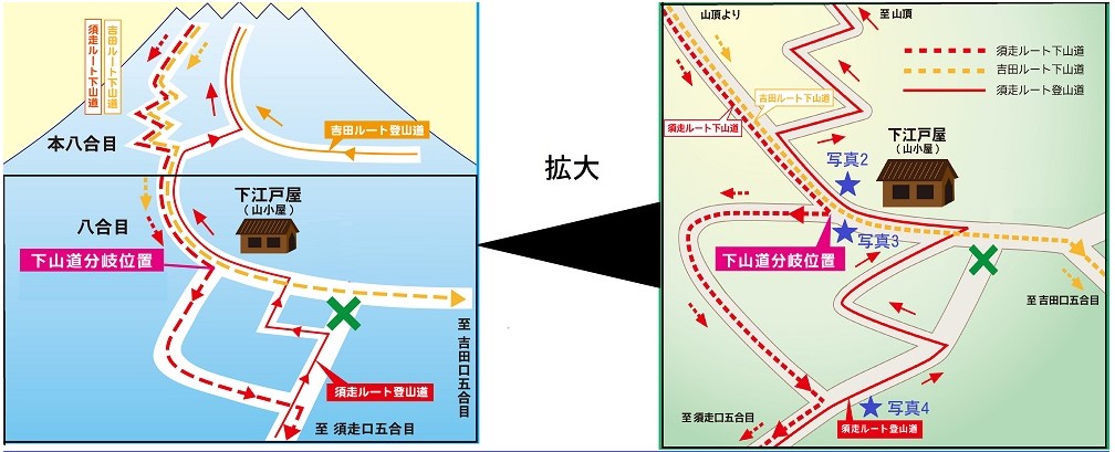
Be careful when descending the Yoshida and Subashiri Trails
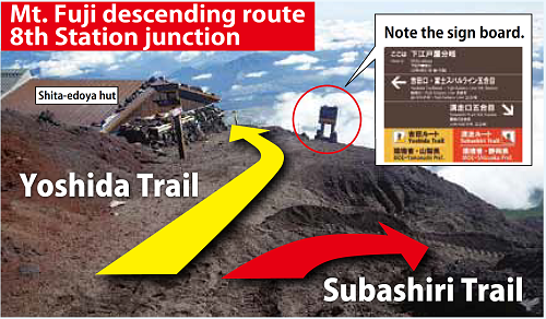
The upper parts of the descending paths of the Yoshida Trail and Subashiri Trail (from the summit to the 8th Station) are merged. This makes it very difficult to find the junction. When you descend to the Yoshida Trail Ent. or Subashiri Trail Ent. from the summit, you can use the same descending trail until the 8th Station, but from there, the descending trail is split into the directions of the Yoshida Trail and the Subashiri Trail.
Every summer, more than 1,000 people take the wrong trail owing to such reasons as poor visibility making it difficult to find the junction and fatigue making them less alert. Please pay attention to the following points when you descend.
• Do not miss the sign at the junction (Yoshida Trail: yellow, Subashiri Trail: red)
• Shita-edoya (mountain lodge) is located at the junction
*Accurate coordinates, topographic map
How to travel between different trailheads (in case you mistakenly descend Subashiri Trail)
If you originally plan to descend Yoshida trail to the Fuji-Subaru Line 5th Station and mistakenly come down to the Subashiri Trail's 5th Station, take a bus or taxi to your proper destination (approx. 30,000 yen). You need to change buses (no direct bus).
1. Subashiri trailhead (5th Station) - Take Fujikyu's shuttle bus to Subashiri Shuttle bus station next to Road Station Subashiri (Michi-no-eki) (about 30 minutes)
2. Road Station Subashiri (Michi-no-eki) - Take a local bus to Kawaguchiko Railway Station (Fujikyu Bus for Kawaguchiko or Fujisan Railway Station) (about 1 hour).
3. Kawaguchiko Railway Station - Take a bus to Fuji-Subaru Line 5th Station, Yoshida trailhead (Fujikyu Bus: last stop of the line bound for the trailhead.) (about 1 hour)