

.jpg)
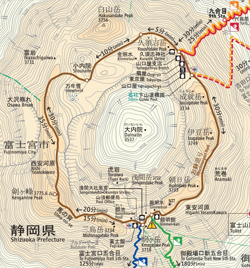
Ohachimeguri Trail (Summit)
- Trail Map
- Course Guide & Important Points
- In-service period
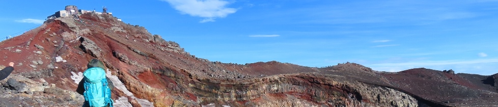
The summit crater-rim laps trail
The trail that leads you around the top of Mt. Fuji is called the Ohachimeguri Trail. Believers of Mt. Fuji worship, called Fujiko, used to visit the shrine at the summit and then walk the Ohachimeguri Trail clockwise. Try to walk the Ohachimeguri Trail when weather is calm and you have enough physical strength. It takes about 90 minutes to go around.
Fujiko: A religious group of Mt. Fuji worship, which flourished in the Edo period.
Precautions
Facilities at the summit
- Public toilets (installed by the Ministry of the Environment): open 04: 00 - 16: 00
- Mountain lodges (Ogiya, Chojo Fujikan, Yamaguchiya Honten)
- Mt. Fuji Summit Post Office: mailing only (from 6:00, July 11 to 14:00, August 19).
- Remains of Mt. Fuji Weather Station: Used for research by the NPO Mount Fuji Research Station. It is not available for public use.
Natural resources and phenomena at the summit
- Kengamine Peak (3,776 m), Mt. Hakusandake, Mt. Kusushidake, Mt. Joju, Mt. Asahidake, Mt. Sengendake, Mt. Komagatake, Mt. Mishimadake
Distinctive rocks
- Toraiwa, Ikazuchigaiwa (lava protruding toward the crater. The rocks resemble the shape of a tiger and lightening)
Kinmeisui (well), Ginmeisui (well)
- sources of spring water at the summit Kinmeisui (well) are located at the foot of Mt. Hakusandake, and Ginmeisui (well) is near the summit of Gotemba Trail.
Konoshiro Pond
- a pond located near the summit (around Okumiya) on the Fujinomiya Trail. This pond can dry up in summer.
Historical resources at the summit
- a branch shrine of Okumiya Shrine located near the summit of the Yoshida and Subashiri Trail. During the climbing season, Shinto priests reside there.
Sengentaisha-Okumiya Shrine at the summit
- located near the summit of the Fujinomiya Trail. During the climbing season, Shinto priests reside there.
Sorry. The page is currently being created.
In-service period of each facility (2023 summer)
| Opening Period | Hours | Remarks | ||
|---|---|---|---|---|
| Trail |
July 10 - September 10 | 24 hours | |
|
Toilet |
Fujinomiya Trail Side |
July 10 - September 10 | 4:00am - 4:00pm | 300 yen (Tip) |
| Yoshida/Subashiri Side |
July 10 - September 10 | 24 hours | ||
Post Office |
July 10 - August 21 | 6:00am - 2:00pm |
Top of the Fujinomiya Trail |
|
Ochudo (trail) (Yamanashi pref. side)
The Ochudo (trail) is an ancient trail of about 25 km for hiking around the 5th Station and was used as a training path for Fujiko worship. It is said that only those who ascended Mt. Fuji three times were allowed to walk Ochudo (trail). There are some dangerous points due to collapses on the Ochudo trail. Now you can hike only about 2.5 km from the Fuji-Subaru Line 5th Station to Oniwa (natural park) on the trail.
-
change in the vehicle restriction on Yamanashi Prefecture toll road (Fuji-Subaru Line)
-
trekking map (English version) to Okuniwa (natural park), Oniwa (natural park) and Ochudo (trail)